Analysis of Satellite Altimetry Data In Monitoring Ocean Waves in the Waters of Bengkulu Province
DOI:
https://doi.org/10.46252/jsai-fpik-unipa.2025.Vol.9.No.2.516Keywords:
altimetry, Bengkulu waters, monsoon, significant wavesAbstract
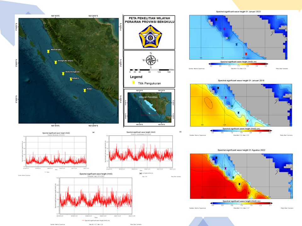
Bengkulu Province, located on the west coast of Sumatra Island and facing directly onto the Indian Ocean, causes sea waves in Bengkulu Waters to be directly influenced by its geographical conditions. Sea waves in Bengkulu Waters vary due to the influence of monsoon winds and global climate. Seasonal variations in significant wave height (SWH) obtained from altimetry satellite imagery in five regions representing Bengkulu, namely Mukomuko Waters, North Bengkulu, Bengkulu City, Seluma, and Kaur can be used to monitor sea waves. The coordinates of the five regions representing Bengkulu Waters are as follows: Mukomuko is located at 2°40'20.82" S, 100°38'47.12" E; North Bengkulu at 3°20'6.55" S, 101°4'59.68" E; Bengkulu City is located at 4°0'7.57" S, 101°31'49.10" E; Seluma is located at 4°20'0.00"S, 102° 0'0.00"E; and Kaur is located at 5°0'59.65"S, 102°49'24.50"E. The data used for five years (2018-2022) is in the form of an average daily SWH every 3 hours and is processed using Panoply software to display the distribution of SWH and time series for each of the five regions in Bengkulu Waters. The results of the study show that the highest sea waves occurred in Kaur Waters, reaching 3.9 meters in August 2022 with an average wave height of 1.73 meters. Meanwhile, the lowest sea wave height occurred in Mukomuko Waters which reached 2.7 meters in January and February 2022, with an average wave height of 0.3 meters. Sea wave height in Mukomuko Waters, North Bengkulu Waters, Bengkulu City Waters, Seluma Waters, and Kaur Waters showed an increasing trend over the past five years. The relationship between significant wave height and season shows a consistent pattern.
Downloads
References
Anggara, P. D., Alam, T. M., Adrianto, D., & Pranowo, W. S. (2018). The wave characteristics in Natuna Sea and its adjacent for naval operation base purposes. IOP Conference Series: Earth and Environmental Science, 176(1). https://doi.org/10.1088/1755-1315/176/1/012003
Arianty, N., Mudin, Y., Rahman, A., & . (2017). Pemodelan Refraksi Gelombang dan Analisis Karakteristik Gelombang Laut di Perairan Teluk Palu. Jurnal Akuntansi, 11(2).
Azhari, F., Pranowo, W. S., Hendra, H., & Umam, C. (2024). Karakter Tinggi Gelombang Laut di Laut Natuna Pada Periode Waktu ENSO (Tahun 2012 s/d 2022). Buletin Oseanografi Marina, 13(1), 21–32. https://doi.org/10.14710/buloma.v13i1.54992
Azies, I. A., Pranowo, W., & Putra, & I. W. S. E. (2021). Sea Surface Stokes Drift Velocity Characteristics In Jakarta Bay 2012 - 2021. International Journal of Intellectual Discourse (IJID), 39(8), 102–111.
Guillou, N. (2020). Estimating wave energy flux from significant wave height and peak period. Renewable Energy, 155, 1383–1393. https://doi.org/10.1016/j.renene.2020.03.124
Haiyqal, S. V., Ismanto, A., Indrayanti, E., & Andrianto, R. (2023). Karakteristik Tinggi Gelombang Laut pada saat Periode Normal, El Niño dan La Niña di Selat Makassar. Jurnal Kelautan Tropis, 26(1), 190–202. https://doi.org/10.14710/jkt.v26i1.17003
Hartono, R., Ary Murti, M., & Alinursafa, I. (2022). 2.Sistem Pemantauan Ketinggian Gelombang dan Ketinggian Permukaan Air Laut Berbasis Internet of Things (Iot) Menggunakan LPWAN LoRa. Snistek, 157–164.
Haryo, J. D. (2024). Variasi Musiman Sea Level Anomaly di Wilayah Perairan Indonesia. 9(September), 200–207.
Mujadida, Z., Setiyono, H., Handoyo, G., Hariyadi, H., & Marwoto, J. (2021). Analisis Dinamika Permukaan Laut di Laut Jawa dengan Recurrent Neural Network Periode 1993 sampai 2019. Indonesian Journal of Oceanography, 3(1), 100–110. https://doi.org/10.14710/ijoce.v3i1.10661
Nooriansyah, S., Fatichah, C., & Sambodho, K. (2018). Analisis Kinerja Metode Artificial Neural Network Dan Support Vector Regression Untuk Prediksi Significant Wave Height. SCAN - Jurnal Teknologi Informasi Dan Komunikasi, 13(1). https://doi.org/10.33005/scan.v13i1.1054
Novian Sangkop, J. D. Mamoto, & M. I., J. (2015). Analisis Pasang Surut di Pantai Bulo Desa Rerer Kecamatan Kombi Kabupaten Minahasa Dengan Metode Admiralty. Tekno, 13(Agustus), 60–69.
Noya, melva E. V. (2023). Dampak Gelombang Kapal Cepat Pada Wilayah Pesisir Pantai Yang Mengakibatkan Abrasi. Balobe Law Journal, 3(1), 8. https://doi.org/10.47268/balobe.v3i1.1366
Pratama, K. R., Siadari, E. L., & Pratama, B. E. (2019). Respon Kejadian Mesoscale Convective System Dengan Gabungan Model Atmosfer-Oseanografi-Hidrodinamika Terhadap Potensi Gelombang Badai Dan Inundasi di Area Pesisir Kepulauan Tanimbar. Jurnal Meteorologi Klimatologi Dan Geofisika, 6(2), 56–63. https://doi.org/10.36754/jmkg.v6i2.124
Prathanazal, M. P., Bandi, S., & Sabri, L. . (2021). Jurnal Geodesi Undip Januari 2021 Analisis Kerentanan Daerah Pesisir Kabupaten Jepara Menggunakan Coastal Vulnerability Index ( Cvi ) Jurnal Geodesi Undip Januari 2021. Cvi.
Pratiwi, N. D. (2024). Estimasi Tinggi Gelombang Signifikan Dipesisir Sengkubang Mempawah Kalimantan Barat. 3(1), 8–16.
Pujol, M. I., Faugère, Y., Taburet, G., Dupuy, S., Pelloquin, C., Ablain, M., & Picot, N. (2016). DUACS DT2014: The new multi-mission altimeter data set reprocessed over 20 years. Ocean Science, 12(5), 1067–1090. https://doi.org/10.5194/os-12-1067-2016
Samdara, R. (2014). Laju Perubahan Muka Air Laut di Wilayah Perairan Pantai Bengkulu Dengan Menggunakan Satelit Altimetry. Jurnal Fisika FLUX, 11(2), 197–203.
Sarsito, D. A., Prijatna, K., Wijaya, D. D., Nur Fajar, T., Radjawane, I. M., Windupranata, W., & Bramanto, B. (2018). Long term variation of sea level anomaly (September 1992-January 2017) in the Indonesian sea from multi-mission satellite altimetry data. IOP Conference Series: Earth and Environmental Science, 162(1). https://doi.org/10.1088/1755-1315/162/1/012043
Silaban, R. A., Nadia Zahrina W, B. Y., & Agassi, 2Rifqi Noval. (2020). Validasi Gelombang Laut di Perairan Teluk Terima Kabupaten Buleleng Provinsi Bali Dengan Software Mike 21. Journal GEEJ, 7(2).
Vignudelli, S., Birol, F., Benveniste, J., Fu, L. L., Picot, N., Raynal, M., & Roinard, H. (2019). Satellite Altimetry Measurements of Sea Level in the Coastal Zone. In Surveys in Geophysics (Vol. 40, Issue 6). Springer Netherlands. https://doi.org/10.1007/s10712-019-09569-1
Downloads
Published
How to Cite
Issue
Section
License
Copyright (c) 2025 Risky Budi Yarmanto, Lizalidiawati, Irkhos, Suhendra

This work is licensed under a Creative Commons Attribution-ShareAlike 4.0 International License.